The storm that pummeled Turlock and much of the state on Wednesday and Thursday will make an encore this weekend and again next week, according to the National Weather Service.
“We see an additional storm moving through this weekend,” said Katrina Hand, a meteorologist with the National Weather Service. “We’ll have moderate to heavy rain pretty much the whole weekend with this system, with about half an inch to one inch of rainfall between Saturday and Sunday that could lead to roadway and urban flooding and some rising of rivers, streams and creeks.”
The storm last week brought anywhere from a one-third of an inch to 1.5 inches closer to the Sierra foothills. Since the start of the NWS water year on Oct. 1, the Modesto region has received 9.29 inches of rain. That’s more than double what’s normal for this time of year (4.23 inches). In December alone, the Modesto region received 6.94 inches of rain, more than three times what’s normal for the month (2.21 inches).
The NWS indicates that Monday and Tuesday will bring the heaviest rainfall, with anywhere from 3 to 4 inches predicted for the county.
“We see a series of storms continuing Monday and Tuesday,” said Hand. “That Monday storm is trending stronger and wetter than the weekend storm.”
Another concern for the NWS is the snow levels. Because the overnight low temperatures for Sunday through Monday are expected to be around 50 degrees, melting snowpack at the lower elevations of the Sierra Nevada could add to any potential flooding.
“At this point it doesn’t look like the main concern,” said Hand. “But it’s definitely something we’re keeping an eye on.”
City of Turlock crews could be seen working around the clock last week, dealing with toppled trees, fallen branches and moderate flooding of some streets, though the extent of the damage is unknown. The city’s Municipal Services Department did not respond to voicemail and email messages seeking comment.
TID reported on Friday that the Tuolumne River Watershed has received 25.56 inches of precipitation since the start of the precipitation year on Sept. 1. That’s 185.2 percent of average-to-date. Of that total, 14.05 aches fell in the watershed in December, more than double the historic average for the month. The watershed has also received 5.86 inches so far this month.
Forecasts for the watershed range from 7 to 9 inches over the next eight days and 10 to 19 inches over the next 16, though, that 16-day forecast continues to evolve, according to Brandon McMillan, communications specialist for TID.
“Locally, there are 4.4 inches of precipitation forecast over the next nine days,” said McMillan. “As such, we anticipate a significant rise in the Tuolumne River channel due to unusually high flows through Dry Creek in Modesto. This rise is a result of heavy rainfall and not TID releases.”
TID experienced a handful of weather-related power outages throughout its service area.
“TID line crews responded quickly to the outages and the majority of impacted customers had their power restored within an hour,” McMillan said. “TID line crews, troubleshooters and other personnel are ready to respond to any outages that occur, but we urge customers to be prepared, stay clear of any fallen lines and report if they experience an outage by calling our 24-hour service line at 209-883-8301.”
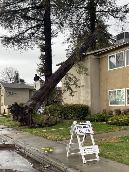
One of the more visible displays of the storm’s might could be seen at an apartment complex on Hawkeye Avenue near Donnelly Park, where a 60-foot redwood toppled over and damaged the second story of the complex.
A resident of the complex told the Journal that nobody was injured and that the tree did not penetrate the roof.
The complex is lined with more than a dozen redwoods similar in size and those remained standing.


