
Voters in Merced County will see a shift in boundary lines the next time they cast ballots for the Board of Supervisors after a new electoral map was chosen by officials last month.
The new map was selected by Supervisors on Dec. 7 after a lengthy redistricting process and features changes to two districts, while leaving the other three close to their previous shapes. Merced County’s redistricting process was completed in collaboration with the National Demographics Corporation, legal consultants Nielsen Merksamer and the communications firm Tripepi Smith, and three prior public hearings had been held in order to receive input on the five final maps that Supervisors were able to choose from.
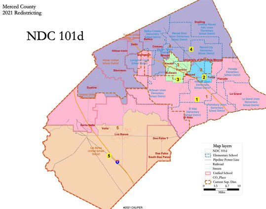
In choosing new map NDC 101d, drawn by the National Demographics Corporation, new boundaries do not split up any cities in the county, but greatly expand District 1 while taking away land from District 5. The changes came in order to ensure every district has an equal population, and District 5 grew by 11.5% since the last census.
“Everywhere in the county grew over the last 10 years, it’s just that the west side and District 5 grew by an even larger percentage than I expected…In a perfect world, [the districts] would all be 52,600 and something votes, and they’d be represented equally by race, creed…But we obviously don’t live in a perfect world,” District 5 Supervisor Scott Silveira said. “Knowing the work ethic of my colleagues up here, I feel like whatever district we end up with, we’re all going to do our best to represent it.”
In the new map, District 1 now extends west into the north end of former District 5, picking up Santa Nella and the surrounding land above the town. Volta and Los Banos remain in District 5. District 2 and District 3 remain unchanged for the most part but do expand south a bit, while the area jutting from District 5 into Livingston has also been expanded slightly from east to west.
District 4 experienced hardly any change, save for several very small expansions southward, and the newly-drawn District retains Gustine, Hilmar, Delhi and Snelling. This map was District 4 Supervisor Lloyd Pareira’s preference because it allowed him to continue representing the constituents he has come to know in his area without expanding the district he’s responsible for.
“Having the most communities in my district has made it a bit difficult because of the number of events,” Pareira said. “A lot of communities have parades, veterans ceremonies, and I want to be able to make them all.”
The changes to District 1 and District 5 allow the new map to meet criteria created by the Voting Rights Act which states that under certain circumstances, minority opportunity districts must be drawn that have at least 50% minority voting age population.
In District 1, 59% of the voting age is Latino compared to 22% white, 14% Asian/Pacific Islander and 4% black. District 5 features a 56% Latino voting age population, with 34% white, 4% Asian/Pacific Islander and 4% black.
District 5 features the highest population at 58,815, and the remaining four districts feature populations of just over 54,000 to about 57,000. In total, Merced County has 281,098 residents.
“It’s very hard trying to do what’s fair and no map is perfect, but there’s always a decision that needs to be made,” District 1 Supervisor Rodrigo Espinoza said.
To view the new Merced County electoral map, visit https://drawmercedcounty.org/selected-map/


